
Cyclone Alert In Bay Of Bengal As Severe Storm Threatens Andhra Pradesh Coast, Heavy Rain Likely In Kolkata & South Bengal
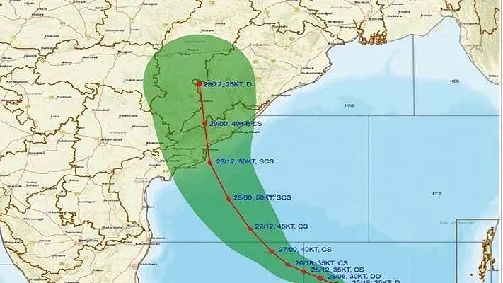
Kolkata, Nov 16: The deep depression over the southeast Bay of Bengal is likely to intensify into a severe cyclonic storm and move towards the Andhra Pradesh coast, the India Meteorological Department (IMD) said on Monday.
The system is not expected to make a direct impact on West Bengal, but its influence is likely to bring rain and thunderstorms to several parts of south Bengal, including Kolkata.
Heavy rainfall has been forecast in a few districts.
Cyclone Alert Over Bay of Bengal!The Deep Depression over the southeast and adjoining southwest Bay of Bengal is very likely to intensify into a Cyclonic Storm by the evening of 16th November, followed by a Severe Cyclonic Storm by 17th November 2026.The system is likely to intensify further and move northwestwards, reaching the westcentral Bay of Bengal near the Andhra Pradesh coast as a Very Severe Cyclonic Storm around the night of 19th November 2026.Stay tuned for the latest weather updates and follow IMD advisories.#IMD #CycloneAlert #BayOfBengal #CyclonicStorm #AndhraPradesh #WeatherUpdate #IMDWeather@moesgoi @airnewsalerts @DDNational @ndmaindia @ICRER_MHA
— India Meteorological Department (@Indiametdept) November 16, 2026
Deep Depression Likely To Intensify
According to the IMD, the depression was moving north-northwestwards at around 8 kmph and intensified into a deep depression by 11:30 p.m. on Sunday.
It was then centred about 670 km west of Srivijayapuram in the Andaman and Nicobar Islands, 640 km east-northeast of Trincomalee in Sri Lanka, 760 km east-southeast of Chennai, 870 km south-southeast of Visakhapatnam and 980 km south-southeast of Gopalpur in Odisha.
The deep depression is likely to continue moving north-northwestwards and intensify into a cyclonic storm by Monday evening.
It is expected to gain further strength on Tuesday and could develop into a severe cyclonic storm by that evening.
Cyclone May Approach Andhra Pradesh Coast
The system is forecast to strengthen further over the sea and reach the Andhra Pradesh coast in the following two days.
It may make landfall as a very severe cyclonic storm, with wind speeds of 120-130 kmph and gusts reaching 145 kmph.
Meteorologists said the system could gain considerable strength because it is expected to remain over the sea for an extended period.
Andhra Pradesh Braces For Heavy Rains As Third Cyclone Forms Along Coast In 20 DaysHeavy Rain Forecast For South Bengal
The weather system is likely to influence conditions in West Bengal from Wednesday.
The IMD has forecast heavy rain in parts of South 24 Parganas, East Midnapore, West Midnapore, Jhargram and Howrah from Thursday.
Gusty winds reaching 40-50 kmph are also likely in these districts.
Other southern districts, including Kolkata, may receive scattered rain accompanied by thunderstorms. Such conditions are likely to continue until Saturday, according to the forecast.
North Bengal is unlikely to be affected by the system, and dry weather is expected to prevail there for now.
Also Watch:
Kolkata Temperatures Likely To Remain Stable
Kolkata recorded a minimum temperature of 22.2 degrees Celsius on Monday morning, 1.9 degrees above normal.
The maximum temperature on Sunday was 29.2 degrees Celsius, 1.4 degrees below normal.
The IMD does not expect any significant change in temperatures across the city over the next few days.
The department said the system's movement and intensification would determine the distribution and intensity of rainfall over the coming days across the affected districts.
Level up your brain the fun way. Play daily games and quizzes on FPJ Smart!
(Except for the headline, this article has not been edited by FPJ's editorial team and is auto-generated from an agency feed.)
This content is published by Free Press Journal and has not been created or edited by Hello Headlines. View original