
Andhra, Odisha step up cyclone preparations as Arnab nears coast
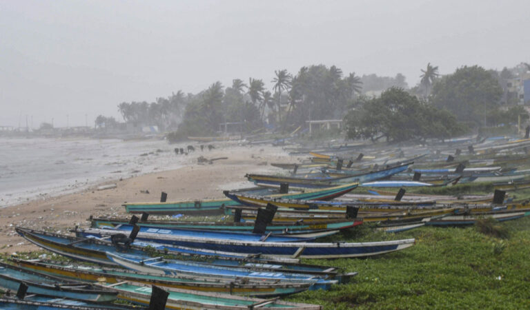
Amaravati/Bhubaneswar: Andhra Pradesh and Odisha have stepped up preparations, including moving people to safer locations, as “very severe” cyclonic storm Arnab heads towards the east coast and is expected to make landfall within the next 24 hours, officials said on Tuesday.
In its latest bulletin, the India Meteorological Department (IMD) said the cyclone was over the Bay of Bengal, about 170 km south-southeast of Visakhapatnam in Andhra Pradesh, at 11.30 am. It is likely to move west-northwestward until evening before crossing the coast between Bapatla and Visakhapatnam, close to Yanam, by Wednesday forenoon.
The system is expected to make landfall with maximum sustained wind speeds of 125-135 kmph, gusting to 150 kmph, the agency said.
Andhra Pradesh has been placed on high alert, with evacuations planned and precautionary measures underway to prevent loss of life and property, officials said.
According to the Andhra Pradesh State Disaster Management Authority (APSDMA), the cyclone’s impact is being felt, with heavy rainfall expected in the north coastal districts shortly. Srikakulam district is likely to experience heavy rain accompanied by strong winds, while strong winds have already begun in Visakhapatnam and Kakinada.
Chief Minister N Chandrababu Naidu directed officials to shift people living in low-lying areas to safer locations, ensure essential supplies at relief camps and minimise cyclone-related damage.
He spoke to collectors of districts likely to be affected and instructed officials to ensure the availability of food, drinking water and other essential supplies at relief camps.
APSDMA Managing Director Prakhar Jain urged people to remain alert and follow safety precautions.
Residents have been advised to stay indoors during the cyclone and avoid venturing outside amid strong winds. They should move to the nearest cyclone shelter if instructed by officials and stay away from the sea, rivers and ponds.
Sea waves are likely to rise to heights of one to two metres, while extremely heavy rainfall is forecast in north Andhra Pradesh and coastal districts as the cyclone approaches.
Jain said 2,131 cyclone shelters had been set up across the state’s 20 districts, and continuous cyclone alerts were being sent to the mobile phones of 2.70 crore people across 18 districts.
More than 30,000 fishing boats have been secured along the coast, while 1,087 medical teams have been deployed in cyclone-affected areas to provide emergency assistance, he said.
Authorities have readied 8,281 emergency beds and 1,274 ambulances, while hospitals have stocked 21,536 doses of anti-snake venom to deal with possible snakebite incidents, officials said.
A total of 1,351 pregnant women have already been shifted safely to hospitals. Drinking water tankers, generators and reverse osmosis (RO) plants have been kept ready, they said.
Two months’ worth of essential commodities have been stocked in advance at 14,686 ration shops, while advisories have been issued to 35.96 lakh farmers to protect their crops from damage, they added.
Indian Railways has placed around 600 km of tracks under close surveillance ahead of the cyclone’s expected landfall, with safety protocols and rapid restoration measures in place across the Vijayawada and Visakhapatnam divisions.
War rooms have been activated at zonal, divisional and Railway Board levels to facilitate round-the-clock monitoring, officials said.
Traffic between Uppada and Kakinada has been disrupted due to rough sea conditions, affecting movement between surrounding coastal areas as waves continue to surge along the shoreline.
Under the impact of the weather system, heavy rain accompanied by strong winds lashed parts of Odisha, where the government aims to move around 48,000 people to safer locations.
Odisha Special Relief Commissioner (SRC) Rajesh P Patil said around 11,000 people each would be shifted to safer locations in Gajapati and Nabarangpur districts.
Evacuation drives were also underway in Malkangiri, Ganjam, Koraput, Rayagada, Kalahandi and Nuapada, he said.
Schools in eight districts have been ordered to remain closed on Tuesday and Wednesday.
The IMD issued an orange warning, forecasting heavy to very heavy rainfall of 12-20 cm, for Puri, Gajapati, Ganjam, Rayagada, Koraput and Malkangiri districts.
A yellow warning, indicating heavy rainfall of 7-11 cm, was issued for Balasore, Bhadrak, Jajpur, Kendrapara, Cuttack, Keonjhar, Mayurbhanj, Kandhamal, Kalahandi, Nabarangpur, Khurda, Nayagarh, Jagatsinghpur, Nuapada, Balangir and Boudh.
Patil said 135 permanent cyclone shelters and around 1,600 temporary shelters had been prepared to accommodate people from vulnerable areas.
The state government has deployed 294 rescue teams across potentially affected areas, including nine National Disaster Response Force (NDRF) teams, 60 State Disaster Response Force (SDRF) teams and 225 Fire Services teams, officials said.
Maintaining that the government had set a “zero casualty” target, Patil said district collectors had been directed to take all necessary measures to protect lives and property.
Disaster Management Minister Suresh Pujari said heavy rain in the upper catchment areas of rivers in Chhattisgarh and Jharkhand could trigger flash floods and waterlogging in western and northern Odisha.
Odisha’s major ports, including Paradip, Dhamra and Gopalpur, have stepped up preparations in view of the approaching storm.
The very severe cyclonic storm also brought rain to parts of West Bengal in the afternoon.
The coastal districts of South 24 Parganas and Purba Medinipur experienced moderate rain, while parts of Jhargram, Paschim Medinipur, Howrah and Kolkata also received rainfall, the IMD said.
The weather department forecast heavy rain in South 24 Parganas, Purba and Paschim Medinipur, Jhargram, Purulia, Bankura and Paschim Bardhaman on October 28 and 29, while Kolkata is likely to receive light to moderate rain.
In the sub-Himalayan region, heavy rain is expected in Darjeeling, Kalimpong, Alipurduar and Jalpaiguri on October 29 and 30, it said.
The cyclone is also expected to bring heavy rainfall to parts of Jharkhand over three days, prompting the state government to ask district administrations to remain vigilant, officials said.
A yellow alert, advising people to stay updated, has been issued for heavy rain in Ranchi, Khunti, Simdega, Gumla, Lohardaga, Saraikela-Kharsawan, East Singhbhum and West Singhbhum for 24 hours from 8.30 am on October 28, the IMD said.
The Ranchi district administration has asked officials to remain vigilant.
“Waterlogging is likely in low-lying areas and on roads in Ranchi due to heavy rainfall. Kutcha houses, shanties and structurally weak buildings may sustain damage. Rivers, lakes and large drains could overflow. There is a possibility of flood-like conditions in low-lying areas,” the administration said in a statement.
This content is published by Telangana Today and has not been created or edited by Hello Headlines. View original